
Maps and… Missiles?
Last night, I spent some time flying over the city of Chicago, then a few moments later I hovered over Manhattan for a bit.
No, I haven’t gotten heavy into the hallucinogens: I was admiring Google Maps, now enhanced with zoomable satellite images (via Keyhole.) Enter an address, flip to satellite mode, and (if the city is big enough to warrant it) zoom in, drag the image around, and just have some fun. Makes TerraServer seem sadly outdated.
The fact that you can sit in your chair and recreate every bad spy movie you’ve ever seen, for free, is great fun.
I wouldn’t recommend using it for actual surveillance work, however, as the images have been, ahem, altered. Take this cropped view of the Casa Blanca:
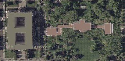
Note the oddly flat, uniform color on the roof of the two buildings, particularly the amateur edges. There’s something up there that the government has decided we shouldn’t see. Missiles, maybe? Snipers? Freaky-cool satellite dishes? Perhaps (shudder) a hot tub?
Who knows. Guess we’ll have to hold out for Yahoo! UAV…